
In 2026, Earth observation is no longer limited by data scarcity—it is shaped by how quickly teams can turn imagery into decisions. That shift is redefining Earth Science Topics across hazards, climate adaptation, water security, and land management. This article explains what “Advanced Geospatial Analysis 2026” means in practice: modern data access patterns, scalable computation, and credible methods for translating pixels into defensible evidence. You will learn how today’s platforms and standards support reproducibility, how GeoAI is changing interpretation, and how to design workflows that remain scientifically transparent. If you work on Earth Science Topics, the goal is simple: faster insight without sacrificing accuracy or traceability.
The 2026 geospatial stack for Earth science
Advanced work on Earth Science Topics increasingly depends on “move compute to data” patterns, especially when archives are too large to download efficiently. NASA highlights cloud computing as a way to scale access and processing as data volumes grow. Platforms built for planetary-scale analysis are now central to many research pipelines, including Google Earth Engine’s multi-petabyte catalog and compute model.
Two practical implications matter for Earth Science Topics:
- You spend more time designing analysis logic and less time managing file transfers.
- You can rerun methods on updated data, supporting more frequent monitoring cycles.
This stack shift also raises the bar for documentation: parameters, training data, and uncertainty reporting become part of the deliverable, not an afterthought—especially when outputs inform policy-relevant Earth Science Topics.
Cloud-native data access and modern standards

A major technical enabler for Earth Science Topics is the growth of cloud-native geospatial standards that separate “where the data is stored” from “how it is discovered and queried.” The Open Geospatial Consortium’s move toward web APIs is intended to support discovery and access across distributed cloud systems, not just single providers.
Catalogs that make data findable
The SpatioTemporal Asset Catalog (STAC) has become widely used for describing and searching geospatial assets, and NASA Earthdata documents its adoption for cloud-based catalog representation and granule queries. For Earth Science Topics, this reduces friction when you need to find the “right” scene: the right time window, footprint, and product lineage.
Formats built for partial reads
For raster work, Cloud Optimized GeoTIFF (COG) is explicitly referenced in NASA Earthdata tooling guidance, aligning with the need to stream only the pixels required for a study area. For vector and tabular analytics, STAC GeoParquet is emerging as a way to store and analyze STAC metadata efficiently as GeoParquet.
For teams tackling Earth Science Topics, the outcome is not merely “faster data.” It is the ability to preserve provenance—catalog + format + method—so results remain auditable.
Advanced methods that matter in 2026
Advanced geospatial analysis is not a single technique. It is a bundle of methods that—when used carefully—improve the credibility and resolution of Earth Science Topics research.
Multi-sensor fusion and temporal analytics
Multi-sensor approaches matter because no single instrument captures everything. Community agendas emphasize combining optical, SAR, and elevation products in cloud-native workflows. When you fuse time series, you can separate seasonal behavior from structural change—critical for Earth Science Topics like deforestation, shoreline migration, and drought response.
Data cubes for repeatable science
Earth observation data cubes organize analysis-ready stacks so the same computation can be repeated across time and space. This concept is widely discussed in Earth observation cloud contexts as a pathway to scalable, repeatable processing. Repeatability is a practical advantage for Earth Science Topics: it makes monitoring programs easier to maintain, review, and extend.
A concrete example is NASA’s Harmonized Landsat Sentinel (HLS) vegetation index products, which expand options for vegetation monitoring by providing derived layers designed for analysis.
GeoAI and foundation models in Earth workflows
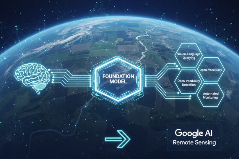
GeoAI is moving from experimentation to operations in many Earth Science Topics. Esri frames geospatial AI as a way to automate monitoring at scale, supporting repeated land-use and land-cover observation. Google’s research updates also describe “Remote Sensing Foundations” capabilities like vision-language querying and open-vocabulary detection, which can accelerate certain interpretation steps.
Where GeoAI adds value—and where it doesn’t
Used well, GeoAI workflows can:
- flag candidate changes for review,
- standardize feature extraction across large regions,
- help triage events for rapid response in Earth Science Topics.
But GeoAI is not a replacement for validation. Models can generalize poorly across regions or seasons, so the scientific requirement remains: transparent training data, documented thresholds, and uncertainty-aware evaluation.
This is where geospatial foundation models are most promising: they can reduce manual labeling burdens, but still require domain checks to ensure outputs are meaningful for Earth Science Topics.
Also Read: DNA vs RNA – 7 Crucial Differences You Must Understand
A practical blueprint for credible analysis in 2026
To compete for trust (and not just speed), advanced work on Earth Science Topics should adopt a workflow blueprint that aligns with the tools and standards now common in the field:
- Define the decision question first (hazard, trend, attribution, forecast).
- Choose discovery and access paths that preserve provenance (catalog + product IDs). For API-first discovery, standards like OGC API – Features represent the direction of interoperable web access.
- Use reproducible compute (scripts/notebooks, pinned versions, fixed random seeds for ML).
- Validate with independent data (field observations, higher-resolution subsets, cross-sensor checks).
- Communicate uncertainty clearly—especially when Earth Science Topics outputs inform planning or regulation.
For practitioners, the win is measurable: less time wrangling inputs, more time validating and interpreting outcomes.
Conclusion
Advanced geospatial analysis in 2026 is defined by scalable compute, cloud-native discovery, and responsible automation. For Earth Science Topics, that means faster monitoring cycles, more repeatable methods, and better traceability from raw scenes to published claims. The strongest projects combine modern catalogs and formats with careful validation, ensuring GeoAI enhances—not obscures—scientific accountability. If you work in Earth Science Topics, treat your workflow as part of the result: document inputs, standards, and uncertainty so others can reproduce what you found and build on it with confidence.